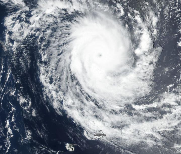
Tropical Cyclone Cilida appeared as a large and powerful hurricane on imagery from NASA-NOAA’s Suomi NPP satellite on Dec. 21. Cilida is located north of the island of Mauritius in the Southern Indian Ocean.
Mauritius has posted warnings for the approaching storm. A tropical cyclone warning Class 2 is in force in Mauritius, and a class 1 warning in Rodrigues. Suomi NPP passed over Cilida on Dec. 21 and the VIIRS instrument provided a visible image. The VIIRS image showed Cilida continued to intensify rapidly. The VIIRS image showed an eye surrounded by powerful storms. The Joint Typhoon Warning Center or JTWC noted, satellite imagery shows the system continued to rapidly intensify as it maintained a 10 nautical mile wide eye and rain bands that wrapped tightly into the center.
At 10 a.m. EDT (1500 UTC) Tropical Cyclone Cilida was located near 15.1 degrees south latitude and 57.7 degrees east longitude. That’s about 301 nautical miles north of Port Louis, Mauritius. Cilida is moving to the south-southwest and has maximum sustained winds near 135 knots (155 mph/250 kph). Cilida is a Category 4 hurricane on the Saffir-Simpson Hurricane Wind Scale.
JTWC forecasters expect Cilida will move south, later southeast as it strengthens to 140 knots after today. Peak intensity will occur as the storm passes between Mauritius and Rodrigues Island. In four days, the storm should transition into an extra-tropical cyclone and rapidly weaken.

